
Hell Bourg topographic map
Interactive map
Click on the map to display elevation.
About this map
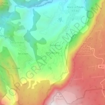
Name: Hell Bourg topographic map, elevation, terrain.
Average elevation: 3,714 ft
Minimum elevation: 1,765 ft
Maximum elevation: 6,250 ft
Other topographic maps
Click on a map to view its topography, its elevation and its terrain.
Hell Bourg
Frankreich > Réunion > Hell Bourg
Hell Bourg, Saint-Benoît, Réunion, Frankreich
Average elevation: 3,409 ft