
Make a donation
Gear up for your next adventure:
As an Amazon Associate, this site earns from qualifying purchases at no extra cost to you.
Gor topographic map
Click on the map to display elevation.
Make a donation
Gear up for your next adventure:
As an Amazon Associate, this site earns from qualifying purchases at no extra cost to you.
Gor
Gor is a town of Granada, in southwestern Spain. It consists of the town center and several suburbs scattered all over its municipal area, such as Las Juntas, Las Viñas, Cenascuras, Los Balcones, La Rambla Valdiquín, Los corrales, El Royo Serval and La Estación de Gorafe. Situated at an altitude of between 1,100 m and 2,100 m above sea level and with an extension of 182 km², Gor has a long history of human settlements that date back to the Paleolithic. The official population of Gor in 2005 was 997.
Make a donation
Gear up for your next adventure:
As an Amazon Associate, this site earns from qualifying purchases at no extra cost to you.
About this map
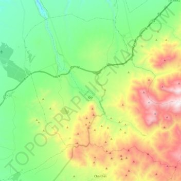
Name: Gor topographic map, elevation, terrain.
Location: Gor, Comarca de Guadix, Granada, Andalusia, 18870, Spain (37.30324 -3.04853 37.44882 -2.83201)
Average elevation: 4,432 ft
Minimum elevation: 2,854 ft
Maximum elevation: 7,290 ft
Make a donation
Gear up for your next adventure:
As an Amazon Associate, this site earns from qualifying purchases at no extra cost to you.
Other topographic maps
Click on a map to view its topography, its elevation and its terrain.
Make a donation
Gear up for your next adventure:
As an Amazon Associate, this site earns from qualifying purchases at no extra cost to you.
Puero de Jeres
Spain > Andalusia > Comarca de Guadix > Jérez del Marquesado
Average elevation: 8,763 ft