Geolocate

Foz topographic map

Interactive map

Click on the map to display elevation.

About this map

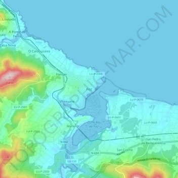
Name: Foz topographic map, elevation, terrain.

Location: Foz, Mariña Central, Lugo, Galicia, 27780, España (43.52887 -7.29504 43.60887 -7.21504)

Average elevation: 141 ft

Minimum elevation: -10 ft

Maximum elevation: 1,142 ft

Other topographic maps

Click on a map to view its topography, its elevation and its terrain.

Fontao

España > Galicia > Mariña Central

Fontao, O Valadouro, Mariña Central, Lugo, Galicia, España

Average elevation: 2,644 ft

Fazouro

España > Galicia > Mariña Central

Fazouro, Foz, Mariña Central, Lugo, Galicia, 27789, España

Average elevation: 344 ft

Mondoñedo

España > Galicia > Mariña Central

Mondoñedo, Mariña Central, Lugo, Galicia, España

Average elevation: 1,168 ft

Pedrouzo

España > Galicia > Mariña Central > Alfoz

Pedrouzo, Alfoz, Mariña Central, Lugo, Galicia, 27776, España

Average elevation: 1,339 ft

A Granda

España > Galicia > Mariña Central > Alfoz

A Granda, San Pedro de Mor, Alfoz, Mariña Central, Lugo, Galicia, 27773, España

Average elevation: 233 ft

Monte de San Pedro

España > Galicia > Mariña Central > Alfoz > Presa Boa

Monte de San Pedro, Presa Boa, Adelán, Alfoz, Mariña Central, Lugo, Galicia, España

Average elevation: 725 ft

Alfoz

España > Galicia > Mariña Central > Alfoz

Alfoz, Mariña Central, Lugo, Galicia, España

Average elevation: 978 ft

Andamil

España > Galicia > Mariña Central > O Valadouro > Andamil

Andamil, O Cadramón, O Valadouro, Mariña Central, Lugo, Galicia, España

Average elevation: 2,001 ft

Lourenzá

España > Galicia > Mariña Central > Lourenzá

Lourenzá, Mariña Central, Lugo, Galicia, España

Average elevation: 853 ft

Cornella

España > Galicia > Mariña Central > Lourenzá > Cornella

Cornella, Lourenzá, Mariña Central, Lugo, Galicia, 27760, España

Average elevation: 374 ft