
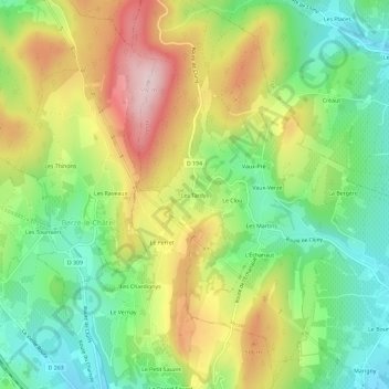
Les Tardys topographic map
Interactive map
Click on the map to display elevation.
About this map
Name: Les Tardys topographic map, elevation, terrain.
Average elevation: 1,322 ft
Minimum elevation: 889 ft
Maximum elevation: 1,913 ft
Other topographic maps
Click on a map to view its topography, its elevation and its terrain.
Vaux-Verzé
France > Bourgogne-Franche-Comté > Saône-et-Loire > Verzé
Vaux-Verzé, Verzé, Mâcon, Saône-et-Loire, Bourgogne-Franche-Comté, France métropolitaine, 71960, France
Average elevation: 1,260 ft
Le Bourbillon
France > Bourgogne-Franche-Comté > Saône-et-Loire > Verzé
Le Bourbillon, Verzé, Mâcon, Saône-et-Loire, Bourgogne-Franche-Comté, France métropolitaine, 71960, France
Average elevation: 1,122 ft
Verchizeuil
France > Bourgogne-Franche-Comté > Saône-et-Loire > Verzé
Verchizeuil, Verzé, Mâcon, Saône-et-Loire, Bourgogne-Franche-Comté, France métropolitaine, 71960, France
Average elevation: 961 ft