
Büdingen topographic map
Interactive map
Click on the map to display elevation.
About this map
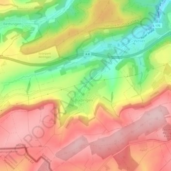
Name: Büdingen topographic map, elevation, terrain.
Location: Büdingen, Merzig, Landkreis Merzig-Wadern, Saarland, Deutschland (49.43102 6.53314 49.46432 6.57046)
Average elevation: 991 ft
Minimum elevation: 594 ft
Maximum elevation: 1,289 ft
Other topographic maps
Click on a map to view its topography, its elevation and its terrain.
Menningen
Deutschland > Saarland > Merzig
Menningen, Merzig, Landkreis Merzig-Wadern, Saarland, Deutschland
Average elevation: 997 ft
Wellingen
Deutschland > Saarland > Merzig
Wellingen, Merzig, Landkreis Merzig-Wadern, Saarland, Deutschland
Average elevation: 1,043 ft
Weiler
Deutschland > Saarland > Merzig
Weiler, Merzig, Landkreis Merzig-Wadern, Saarland, Deutschland
Average elevation: 886 ft
Harlingen
Deutschland > Saarland > Merzig
Harlingen, Merzig, Landkreis Merzig-Wadern, Saarland, Deutschland
Average elevation: 817 ft