
Thank you for supporting this site ❤️
Make a donation
Make a donation
Gear up for your next adventure:
As an Amazon Associate, this site earns from qualifying purchases at no extra cost to you.
Roughton topographic map
Click on the map to display elevation.
Thank you for supporting this site ❤️
Make a donation
Make a donation
Gear up for your next adventure:
As an Amazon Associate, this site earns from qualifying purchases at no extra cost to you.
About this map
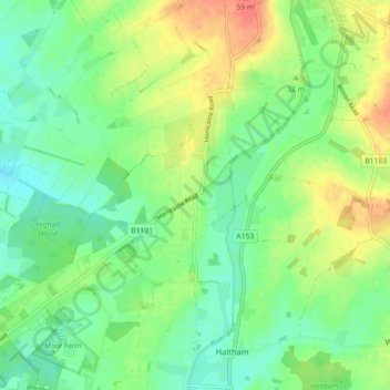
Name: Roughton topographic map, elevation, terrain.
Location: Roughton, East Lindsey, Lincolnshire, England, United Kingdom (53.15117 -0.19675 53.20479 -0.11310)
Average elevation: 92 ft
Minimum elevation: 30 ft
Maximum elevation: 187 ft
Thank you for supporting this site ❤️
Make a donation
Make a donation
Gear up for your next adventure:
As an Amazon Associate, this site earns from qualifying purchases at no extra cost to you.
Other topographic maps
Click on a map to view its topography, its elevation and its terrain.
Saltfleetby St Peter
United Kingdom > England > Lincolnshire > East Lindsey > Saltfleetby St Peter
Average elevation: 10 ft