
Make a donation
Gear up for your next adventure:
As an Amazon Associate, this site earns from qualifying purchases at no extra cost to you.
Sololá - Tz'olöj Ya' topographic map
Click on the map to display elevation.
Make a donation
Gear up for your next adventure:
As an Amazon Associate, this site earns from qualifying purchases at no extra cost to you.
About this map
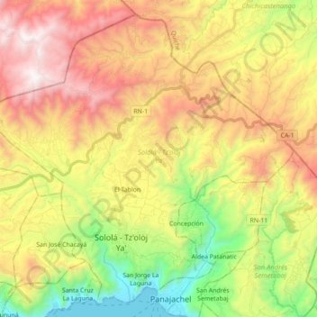
Name: Sololá - Tz'olöj Ya' topographic map, elevation, terrain.
Location: Sololá - Tz'olöj Ya', Sololá, Guatemala (14.73908 -91.26261 14.89342 -91.08788)
Average elevation: 7,785 ft
Minimum elevation: 5,075 ft
Maximum elevation: 10,801 ft
Make a donation
Gear up for your next adventure:
As an Amazon Associate, this site earns from qualifying purchases at no extra cost to you.
Other topographic maps
Click on a map to view its topography, its elevation and its terrain.
Panajachel
Guatemala > Sololá > Panajachel > Panajachel
Panajachel (Spanish pronunciation: , Pana) is a town in the southwestern Guatemalan Highlands, less than 140 kilometres (90 mi) from Guatemala City, in the department of Sololá. It serves as the administrative centre for the surrounding municipality of the same name. The elevation is 1,597 metres (5,240 ft).…
Average elevation: 5,955 ft
Make a donation
Gear up for your next adventure:
As an Amazon Associate, this site earns from qualifying purchases at no extra cost to you.