
't Haantje topographic map
Interactive map
Click on the map to display elevation.
About this map
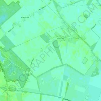
Name: 't Haantje topographic map, elevation, terrain.
Location: 't Haantje, Coevorden, Drenthe, Nederland (52.80193 6.79559 52.81996 6.84981)
Average elevation: 59 ft
Minimum elevation: 43 ft
Maximum elevation: 79 ft
Other topographic maps
Click on a map to view its topography, its elevation and its terrain.
Veenhuizen
Nederland > Drenthe > Coevorden > Dalen
Veenhuizen, Dalen, Coevorden, Drenthe, Nederland, 7751 SR, Nederland
Average elevation: 39 ft
Oosterhesselen
Nederland > Drenthe > Coevorden
Oosterhesselen, Coevorden, Drenthe, Nederland
Average elevation: 49 ft
Noord-Sleen
Nederland > Drenthe > Coevorden
Noord-Sleen, Coevorden, Drenthe, Nederland
Average elevation: 59 ft
Schoonoord
Nederland > Drenthe > Coevorden
Schoonoord, Coevorden, Drenthe, Nederland
Average elevation: 62 ft
Wezuperbrug
Nederland > Drenthe > Coevorden
Wezuperbrug, Coevorden, Drenthe, Nederland
Average elevation: 66 ft
De Klencke
Nederland > Drenthe > Coevorden
De Klencke, Klenkerweg, Oosterhesselen, Coevorden, Drenthe, Nederland, 7861TC, Nederland
Average elevation: 49 ft