
Kandersteg topographic map
Interactive map
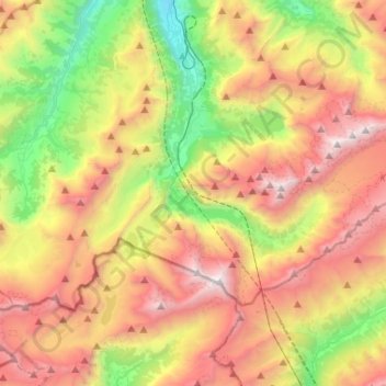
Click on the map to display elevation.
About this map
Name: Kandersteg topographic map, elevation, terrain.
Average elevation: 6,991 ft
Minimum elevation: 2,664 ft
Maximum elevation: 12,041 ft
Kandersteg is located on the northern side of the Bernese Alps at an altitude of 1,200 meters (3,900 ft) above sea level at the foot of the Lötschen and Gemmi Passes. The village, with 1200 inhabitants, lies in the upper Kander Valley. The municipality extends over a territory encompassing the valleys of Gastern (upper Kander Valley) and Oeschinen. It includes the villages of Kandersteg and Gastern.
Other topographic maps
Click on a map to view its topography, its elevation and its terrain.
Kiental
Switzerland > Bern > Frutigen-Niedersimmental administrative district > Reichenbach im Kandertal
Kiental, Reichenbach im Kandertal, Frutigen-Niedersimmental administrative district, Oberland administrative region, Bern, 3723, Switzerland
Average elevation: 4,472 ft
Frutigen
Switzerland > Bern > Frutigen-Niedersimmental administrative district
Frutigen, Frutigen-Niedersimmental administrative district, Oberland administrative region, Bern, Switzerland
Average elevation: 4,938 ft