Beg Ar Bereneg topographic map
Interactive map
Click on the map to display elevation.
About this map
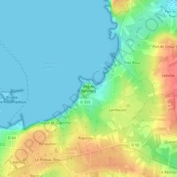
Name: Beg Ar Bereneg topographic map, elevation, terrain.
Average elevation: 69 ft
Minimum elevation: -3 ft
Maximum elevation: 197 ft

Click on the map to display elevation.
Name: Beg Ar Bereneg topographic map, elevation, terrain.
Average elevation: 69 ft
Minimum elevation: -3 ft
Maximum elevation: 197 ft