
Neustift im Stubaital topographic map
Interactive map
Click on the map to display elevation.
About this map
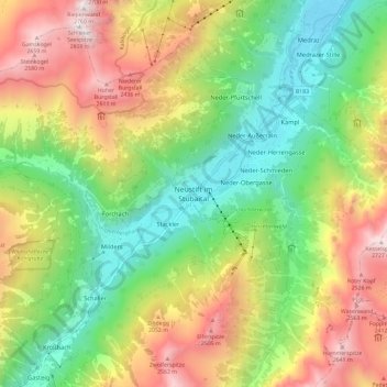
Name: Neustift im Stubaital topographic map, elevation, terrain.
Average elevation: 5,486 ft
Minimum elevation: 2,979 ft
Maximum elevation: 9,052 ft
Der Hauptort der Gemeinde ist das Dorf Neustift im Stubaital. Es befindet sich etwa 20 Kilometer Luftlinie südöstlich vom Stadtzentrum Innsbruck. Es liegt auf um die 990 m ü. A. Höhe im Talgrund des hinteren Stubaitals links der Ruetz.
Other topographic maps
Click on a map to view its topography, its elevation and its terrain.
Ruetz
Österreich > Tirol > Neustift im Stubaital
Ruetz, Neustift im Stubaital, Innsbruck-Land, Tirol, Österreich
Average elevation: 8,107 ft