
Vondo Dam topographic map
Interactive map
Click on the map to display elevation.
About this map
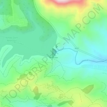
Name: Vondo Dam topographic map, elevation, terrain.
Location: Vondo Dam, Thulamela Local Municipality, Limpopo, RSA (-22.95156 30.35183 -22.94908 30.35286)
Average elevation: 2,979 ft
Minimum elevation: 2,612 ft
Maximum elevation: 3,717 ft
Other topographic maps
Click on a map to view its topography, its elevation and its terrain.
Mutshindudi
RSA > Limpopo > Thulamela Local Municipality
Mutshindudi, Thulamela Local Municipality, Limpopo, RSA
Average elevation: 1,624 ft
Makuleke
RSA > Limpopo > Thulamela Local Municipality
Makuleke, D3639, Thulamela Ward 7, Thulamela Local Municipality, Limpopo, RSA
Average elevation: 1,368 ft
Luvuvhu
RSA > Limpopo > Thulamela Local Municipality
Luvuvhu, Thulamela Local Municipality, Limpopo, RSA
Average elevation: 1,677 ft