
Lac Upemba topographic map
Interactive map
Click on the map to display elevation.
About this map
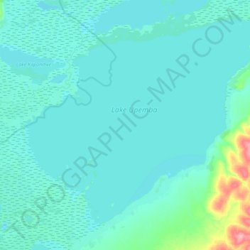
Name: Lac Upemba topographic map, elevation, terrain.
Location: Lac Upemba, Haut-Lomami, RD Congo (-8.78601 26.23409 -8.49818 26.57318)
Average elevation: 1,877 ft
Minimum elevation: 1,844 ft
Maximum elevation: 2,208 ft
Other topographic maps
Click on a map to view its topography, its elevation and its terrain.
Lac Mulenda
RD Congo > Haut-Lomami > Bukama
Lac Mulenda, Bukama, Haut-Lomami, RD Congo
Average elevation: 1,867 ft