
Aït Chafâa topographic map
Interactive map
Click on the map to display elevation.
About this map
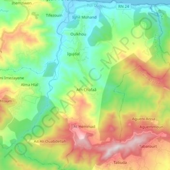
Name: Aït Chafâa topographic map, elevation, terrain.
Location: Aït Chafâa, Daïra Azeffoun, Tizi Ouzou, Algérie (36.76536 4.46188 36.88614 4.59937)
Average elevation: 1,335 ft
Minimum elevation: -10 ft
Maximum elevation: 3,704 ft
La commune d'Aït Chafâa est composée de deux tribus (imravden) .de grande Kabylie. Iazouzen au sud, tribu de haute montagne à près de 1000 mètres d'altitude redescendant ainsi jusque Tighrin au nord , tribu maritime.
Other topographic maps
Click on a map to view its topography, its elevation and its terrain.
Aït Hemmad
Algérie > Tizi Ouzou > Daïra Azeffoun > Aït Chafâa
Aït Hemmad, Aït Chafâa, Daïra Azeffoun, Tizi Ouzou, Algérie
Average elevation: 2,178 ft