
Make a donation
Gear up for your next adventure:
As an Amazon Associate, this site earns from qualifying purchases at no extra cost to you.
Cantón Zarcero topographic map
Click on the map to display elevation.
Make a donation
Gear up for your next adventure:
As an Amazon Associate, this site earns from qualifying purchases at no extra cost to you.
Cantón Zarcero
Zarcero has an area of 155.13 km² and a mean elevation of 1,777 metres.
Make a donation
Gear up for your next adventure:
As an Amazon Associate, this site earns from qualifying purchases at no extra cost to you.
About this map
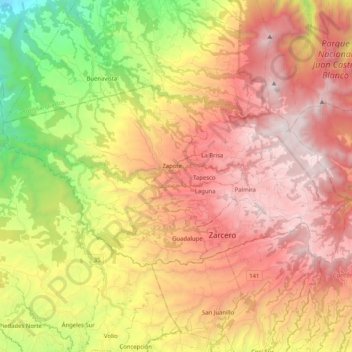
Name: Cantón Zarcero topographic map, elevation, terrain.
Location: Cantón Zarcero, Alajuela Province, Costa Rica (10.16725 -84.51831 10.27042 -84.31440)
Average elevation: 4,400 ft
Minimum elevation: 748 ft
Maximum elevation: 7,530 ft
Make a donation
Gear up for your next adventure:
As an Amazon Associate, this site earns from qualifying purchases at no extra cost to you.
Other topographic maps
Click on a map to view its topography, its elevation and its terrain.
Valle Azul
Costa Rica > Alajuela Province > Cantón de San Ramón > San Lorenzo
Average elevation: 741 ft
La Catarata
Costa Rica > Alajuela Province > Cantón de San Carlos > La Fortuna
Average elevation: 1,306 ft
Make a donation
Gear up for your next adventure:
As an Amazon Associate, this site earns from qualifying purchases at no extra cost to you.
Make a donation
Gear up for your next adventure:
As an Amazon Associate, this site earns from qualifying purchases at no extra cost to you.