Geolocate

Wroxham topographic map

Click on the map to display elevation.

About this map

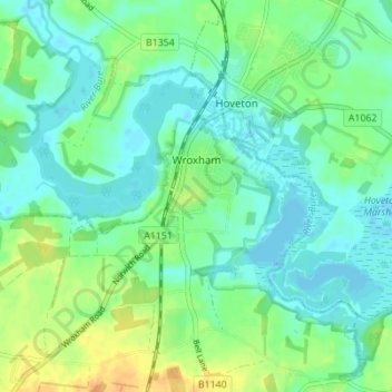
Name: Wroxham topographic map, elevation, terrain.

Location: Wroxham, Broadland, Norfolk, England, United Kingdom (52.68956 1.35505 52.71567 1.42402)

Average elevation: 33 ft

Minimum elevation: -7 ft

Maximum elevation: 105 ft

Other topographic maps

Click on a map to view its topography, its elevation and its terrain.

Thorpe End

United Kingdom > England > Norfolk > Broadland

Average elevation: 102 ft

Strumpshaw Hill

United Kingdom > England > Norfolk > Broadland

Average elevation: 62 ft

New Rackheath

United Kingdom > England > Norfolk > Broadland

Average elevation: 92 ft

Gear up for your next adventure:

🧦Hiking Socks - Comfortable socks to prevent blisters on long hikes
🪶Paracord Bracelet - Survival bracelet with built‑in tools
🌄Hiking Binoculars - Compact binoculars for scenic views and trail spotting
💧Water Filtration Bottles - Safely drink from streams and lakes while exploring
🪄Magnetic Compass - Accurate compass for navigation

As an Amazon Associate, this site earns from qualifying purchases at no extra cost to you.