
Make a donation
Gear up for your next adventure:
As an Amazon Associate, this site earns from qualifying purchases at no extra cost to you.
Ben Macdui topographic map
Click on the map to display elevation.
Make a donation
Gear up for your next adventure:
As an Amazon Associate, this site earns from qualifying purchases at no extra cost to you.
Ben Macdui
Ben Macdui (Scottish Gaelic: Beinn Mac Duibh, meaning "Mac Duff's Hill") is the second-highest mountain in Scotland (and all of the British Isles) after Ben Nevis, and the highest in the Cairngorm Mountains and the wider Cairngorms National Park. The summit elevation is 1,309 metres (4,295 feet) AMSL. Ben Macdui lies on the southern edge of the Cairngorm plateau, on the boundary between the historic counties of Aberdeenshire and Banffshire (currently on the border between the Aberdeenshire and Moray council areas).
Make a donation
Gear up for your next adventure:
As an Amazon Associate, this site earns from qualifying purchases at no extra cost to you.
About this map
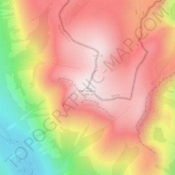
Name: Ben Macdui topographic map, elevation, terrain.
Location: Ben Macdui, Aberdeenshire, Scotland, United Kingdom (57.07034 -3.66918 57.07044 -3.66908)
Average elevation: 3,383 ft
Minimum elevation: 1,886 ft
Maximum elevation: 4,304 ft
Make a donation
Gear up for your next adventure:
As an Amazon Associate, this site earns from qualifying purchases at no extra cost to you.
Other topographic maps
Click on a map to view its topography, its elevation and its terrain.