
Make a donation
Gear up for your next adventure:
As an Amazon Associate, this site earns from qualifying purchases at no extra cost to you.
Vitoria-Gasteiz topographic map
Click on the map to display elevation.
Make a donation
Gear up for your next adventure:
As an Amazon Associate, this site earns from qualifying purchases at no extra cost to you.
Vitoria-Gasteiz
Vitoria-Gasteiz has an oceanic climate (Köppen climate classification: Cfb). Winters are much cooler than in lowland coastal areas, whilst summers are similar in terms of high temperatures, with cool nights due to the elevation. Summers show a significant influence of mediterranean precipitation patterns, but enough precipitation usually occurs to remain marine in nature. Sunshine levels are low by Spanish standards and the climate is humid year-round.
Make a donation
Gear up for your next adventure:
As an Amazon Associate, this site earns from qualifying purchases at no extra cost to you.
About this map
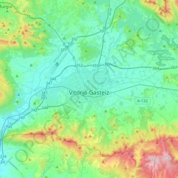
Name: Vitoria-Gasteiz topographic map, elevation, terrain.
Average elevation: 2,054 ft
Minimum elevation: 1,558 ft
Maximum elevation: 3,829 ft
Make a donation
Gear up for your next adventure:
As an Amazon Associate, this site earns from qualifying purchases at no extra cost to you.
Other topographic maps
Click on a map to view its topography, its elevation and its terrain.
Araneta
Spain > Autonomous Community of the Basque Country > Gasteizko kuadrilla/Cuadrilla de Vitoria > Vitoria-Gasteiz > Bolívar
Average elevation: 2,051 ft