
Nghe An province topographic map
Interactive map
Click on the map to display elevation.
About this map
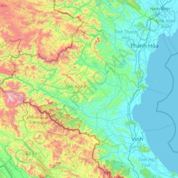
Name: Nghe An province topographic map, elevation, terrain.
Location: Nghe An province, Vietnam (18.55212 103.87456 19.99840 106.16647)
Average elevation: 1,572 ft
Minimum elevation: -3 ft
Maximum elevation: 8,356 ft
Other topographic maps
Click on a map to view its topography, its elevation and its terrain.
Cam Lâm
Vietnam > Nghe An province > Con Cuông District
Cam Lâm, Con Cuông District, Nghệ An Province, Vietnam
Average elevation: 331 ft
Con Cuông District
Con Cuông District, Nghệ An Province, Vietnam
Average elevation: 1,411 ft
X. Nghi Liên
Vietnam > Nghe An province > Vinh > X. Nghi Liên
X. Nghi Liên, Vinh, Nghe An province, Vietnam
Average elevation: 20 ft