
Make a donation
Gear up for your next adventure:
As an Amazon Associate, this site earns from qualifying purchases at no extra cost to you.
Lindau (Bodensee) topographic map
Click on the map to display elevation.
Make a donation
Gear up for your next adventure:
As an Amazon Associate, this site earns from qualifying purchases at no extra cost to you.
About this map
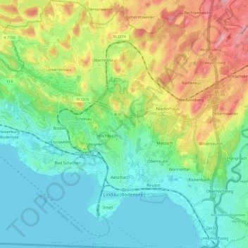
Name: Lindau (Bodensee) topographic map, elevation, terrain.
Location: Lindau (Bodensee), Landkreis Lindau, Bavaria, 88131, Germany (47.53366 9.63623 47.61207 9.74084)
Average elevation: 1,470 ft
Minimum elevation: 1,283 ft
Maximum elevation: 1,841 ft
Make a donation
Gear up for your next adventure:
As an Amazon Associate, this site earns from qualifying purchases at no extra cost to you.
Other topographic maps
Click on a map to view its topography, its elevation and its terrain.
Make a donation
Gear up for your next adventure:
As an Amazon Associate, this site earns from qualifying purchases at no extra cost to you.
Schreckenmanklitz
Germany > Bavaria > Landkreis Lindau > Weiler-Simmerberg
Average elevation: 2,352 ft