
Santa Barbara topographic map
Click on the map to display elevation.
Santa Barbara
The topography of Santa Barbara varies from slightly rolling hills to almost flat or gradually inclined plains, sliced by Tigum River at its centremost, which flows from the north-west to the southeast and the Aganan River in the southern section.
About this map
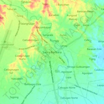
Name: Santa Barbara topographic map, elevation, terrain.
Location: Santa Barbara, Iloilo, Western Visayas, 5002, Philippines (10.78723 122.49147 10.86723 122.57147)
Average elevation: 112 ft
Minimum elevation: 33 ft
Maximum elevation: 259 ft