
Make a donation
Gear up for your next adventure:
As an Amazon Associate, this site earns from qualifying purchases at no extra cost to you.
Maryborough topographic map
Click on the map to display elevation.
Make a donation
Gear up for your next adventure:
As an Amazon Associate, this site earns from qualifying purchases at no extra cost to you.
Maryborough
Maryborough enjoys a temperate climate with four distinct seasons and is typically dry and mild. The mean minimum January temperature 12.9 °C (55.2 °F) with the maximum a balmy 28.8 °C (83.8 °F), however temperatures above 35 °C (95 °F) are commonly recorded during the summer months. The highest temperature ever recorded was 45.4 °C (113.7 °F) on 7 February 2009. The mean minimum temperature in July is 3.4 °C (38.1 °F), with and average maximum of 12.2 °C (54.0 °F). The lowest ever recorded minimum in the city was −4.6 °C (23.7 °F) on 21 July 1982. Although the city experiences little snow due to its low elevation, frosts are common during the colder winter months.
Make a donation
Gear up for your next adventure:
As an Amazon Associate, this site earns from qualifying purchases at no extra cost to you.
About this map
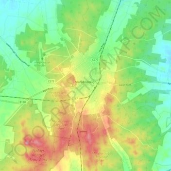
Name: Maryborough topographic map, elevation, terrain.
Average elevation: 781 ft
Minimum elevation: 636 ft
Maximum elevation: 984 ft
Make a donation
Gear up for your next adventure:
As an Amazon Associate, this site earns from qualifying purchases at no extra cost to you.