
Riversdale Beach topographic map
Interactive map
Click on the map to display elevation.
About this map
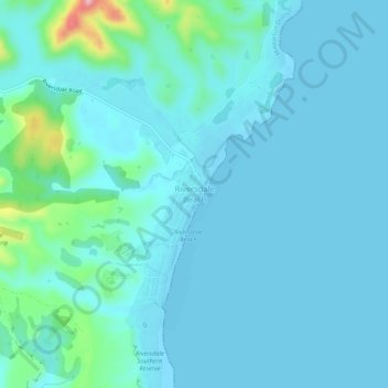
Name: Riversdale Beach topographic map, elevation, terrain.
Location: Riversdale Beach, Masterton, Wellington, New Zealand (-41.10881 176.05351 -41.06881 176.09351)
Average elevation: 66 ft
Minimum elevation: 0 ft
Maximum elevation: 541 ft
Other topographic maps
Click on a map to view its topography, its elevation and its terrain.
Wairarapa
New Zealand > Wellington > Masterton
Wairarapa, Masterton, Wellington, 5871, New Zealand
Average elevation: 328 ft
Castlepoint
New Zealand > Wellington > Masterton
Castlepoint, Masterton, Wellington, New Zealand
Average elevation: 95 ft