Geolocate

Bangcusay topographic map

Click on the map to display elevation.

About this map
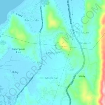
Name: Bangcusay topographic map, elevation, terrain.

Location: Bangcusay, San Fernando, La Union, Ilocos Region, 2500, Philippines (16.62652 120.31979 16.66652 120.35979)

Average elevation: 125 ft

Minimum elevation: -3 ft

Maximum elevation: 738 ft

Other topographic maps

Click on a map to view its topography, its elevation and its terrain.
Gear up for your next adventure:

🛡️Bear Spray Outdoor - Protection in bear country hikes
🔭Compact Binoculars - HD vision for scouting terrain and identifying distant landmarks
🧥Waterproof Jacket for Hiking - Breathable and rugged rain jacket for outdoor excursions
🧭Pro Hiking Compasses - High-accuracy liquid-filled compasses for topographic orientation
🌡️Handheld Weather Meters - Measure wind, temp, and pressure for safe mountain travel

As an Amazon Associate, this site earns from qualifying purchases at no extra cost to you.