Geolocate

Skenfrith topographic map

Click on the map to display elevation.

About this map

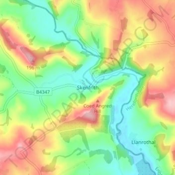
Name: Skenfrith topographic map, elevation, terrain.

Location: Skenfrith, Monmouthshire, Wales, NP7 8UG, United Kingdom (51.85756 -2.80973 51.89756 -2.76973)

Average elevation: 328 ft

Minimum elevation: 108 ft

Maximum elevation: 620 ft

Other topographic maps

Click on a map to view its topography, its elevation and its terrain.

Wye Valley

United Kingdom > Wales > Monmouthshire

Average elevation: 548 ft

Chepstow Castle

United Kingdom > Wales > Monmouthshire > Chepstow

Average elevation: 174 ft

Penallt

United Kingdom > Wales > Monmouthshire

Average elevation: 571 ft

Crucorney

United Kingdom > Wales > Monmouthshire

Average elevation: 974 ft

Blorenge

United Kingdom > Wales > Monmouthshire > Govilon

Average elevation: 1,293 ft

River Monnow

United Kingdom > Wales > Monmouthshire

Average elevation: 564 ft

Llanbadoc

United Kingdom > Wales > Monmouthshire

Average elevation: 256 ft

Raglan Castle

United Kingdom > Wales > Monmouthshire > Raglan

Average elevation: 194 ft

River Monnow

United Kingdom > Wales > Monmouthshire

Average elevation: 564 ft

Gear up for your next adventure:

🧥Waterproof Jacket for Hiking - Breathable and rugged rain jacket for outdoor excursions
🚪Portable Camp Chair - Foldable chair for comfort at camp
🔋Solar Power Banks - Keep your GPS and phone charged in remote wilderness areas
📦Dry Bags Set - Waterproof storage for electronics and clothes
🛡️Bear Spray Outdoor - Protection in bear country hikes

As an Amazon Associate, this site earns from qualifying purchases at no extra cost to you.