
Thank you for supporting this site ❤️
Make a donation
Make a donation
Gear up for your next adventure:
As an Amazon Associate, this site earns from qualifying purchases at no extra cost to you.
Duggingen topographic map
Click on the map to display elevation.
Thank you for supporting this site ❤️
Make a donation
Make a donation
Gear up for your next adventure:
As an Amazon Associate, this site earns from qualifying purchases at no extra cost to you.
About this map
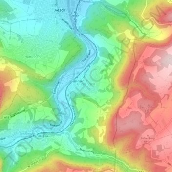
Name: Duggingen topographic map, elevation, terrain.
Location: Duggingen, Bezirk Laufen, Basel-Landschaft, 4202, Switzerland (47.43270 7.59393 47.47045 7.62607)
Average elevation: 1,519 ft
Minimum elevation: 978 ft
Maximum elevation: 2,310 ft
Thank you for supporting this site ❤️
Make a donation
Make a donation
Gear up for your next adventure:
As an Amazon Associate, this site earns from qualifying purchases at no extra cost to you.