
Bharmour topographic map
Interactive map
Click on the map to display elevation.
About this map
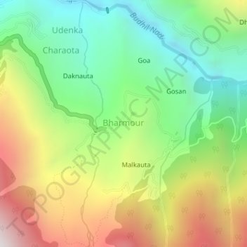
Name: Bharmour topographic map, elevation, terrain.
Location: Bharmour, Brahmaur, Chamba, Himachal Pradesh, 176315, India (32.43996 76.53340 32.44322 76.53946)
Average elevation: 7,231 ft
Minimum elevation: 5,335 ft
Maximum elevation: 9,993 ft
Other topographic maps
Click on a map to view its topography, its elevation and its terrain.
Hadsar
India > Himachal Pradesh > Brahmaur
Hadsar, Brahmaur, Chamba District, Himachal Pradesh, India
Average elevation: 7,877 ft
Samra
India > Himachal Pradesh > Brahmaur > Orai
Samra, Orai, Brahmaur, Chamba District, Himachal Pradesh, India
Average elevation: 7,900 ft
Gauri Kund
India > Himachal Pradesh > Brahmaur
Gauri Kund, Brahmaur, Chamba, Himachal Pradesh, India
Average elevation: 13,730 ft