
Angelochori topographic map
Interactive map
Click on the map to display elevation.
About this map
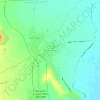
Name: Angelochori topographic map, elevation, terrain.
Average elevation: 66 ft
Minimum elevation: 26 ft
Maximum elevation: 148 ft
Other topographic maps
Click on a map to view its topography, its elevation and its terrain.
Mavri petra
Greece > Macedonia and Thrace > Imathia Regional Unit
Mavri petra, Naousa Municipality, Imathia Regional Unit, Central Macedonia, Macedonia and Thrace, Greece
Average elevation: 5,791 ft
Καστανιά
Greece > Macedonia and Thrace > Imathia Regional Unit > Veria Municipality
Καστανιά, Veria Municipality, Imathia Regional Unit, Central Macedonia, Macedonia and Thrace, Greece
Average elevation: 4,705 ft
Kastania
Greece > Macedonia and Thrace > Imathia Regional Unit > Kastania
Kastania, Δήμος Βέροιας, Imathia Regional Unit, Central Macedonia, Macedonia and Thrace, Greece
Average elevation: 3,914 ft
Rachi
Greece > Macedonia and Thrace > Imathia Regional Unit > Rachi
Rachi, Δήμος Βέροιας, Imathia Regional Unit, Central Macedonia, Macedonia and Thrace, Greece
Average elevation: 1,211 ft
Veria Municipality
Greece > Macedonia and Thrace > Imathia Regional Unit
Veria Municipality, Imathia Regional Unit, Central Macedonia, Macedonia and Thrace, Greece
Average elevation: 1,818 ft