
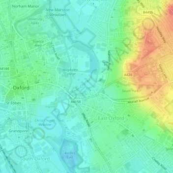
Angel and Greyhound Meadow topographic map
Interactive map
Click on the map to display elevation.
About this map
Name: Angel and Greyhound Meadow topographic map, elevation, terrain.
Average elevation: 223 ft
Minimum elevation: 164 ft
Maximum elevation: 361 ft
Other topographic maps
Click on a map to view its topography, its elevation and its terrain.
Headington Hill Park
United Kingdom > England > Oxford
Headington Hill Park, New Marston, Oxford, Oxfordshire, South East, England, United Kingdom
Average elevation: 243 ft
Binsey
United Kingdom > England > Oxford > Binsey
Binsey, Oxford, Oxfordshire, South East England, England, OX2 0NG, United Kingdom
Average elevation: 226 ft
Blackbird Leys
United Kingdom > England > Oxford
Blackbird Leys, Oxford, Oxfordshire, South East, England, United Kingdom
Average elevation: 223 ft
Godstow
United Kingdom > England > Oxford > Godstow
Godstow, Oxford, Oxfordshire, South East, England, OX2 8PN, United Kingdom
Average elevation: 233 ft
Hinksey Stream
United Kingdom > England > Oxford
Hinksey Stream, Oxford, Oxfordshire, South East, England, OX1 4SY, United Kingdom
Average elevation: 213 ft
Bury Knowle Park
United Kingdom > England > Oxford
Bury Knowle Park, Headington, Oxford, Oxfordshire, South East, England, United Kingdom
Average elevation: 308 ft
Risinghurst and Sandhills
United Kingdom > England > Oxford
Risinghurst and Sandhills, Oxford, Oxfordshire, South East, England, United Kingdom
Average elevation: 351 ft
Castle Mill Stream
United Kingdom > England > Oxford
Castle Mill Stream, Oxford, Oxfordshire, South East, England, OX1 1HF, United Kingdom
Average elevation: 200 ft