
Valdelinares topographic map
Interactive map
Click on the map to display elevation.
About this map
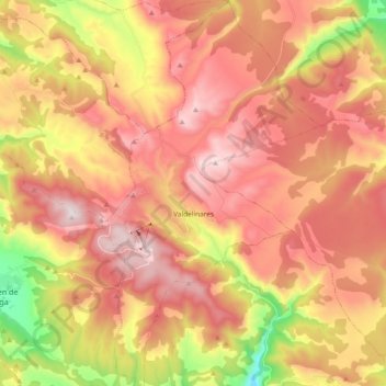
Name: Valdelinares topographic map, elevation, terrain.
Location: Valdelinares, Gúdar-Javalambre, Teruel, Aragon, Spain (40.32767 -0.65037 40.47014 -0.54458)
Average elevation: 5,653 ft
Minimum elevation: 4,262 ft
Maximum elevation: 6,617 ft
The elevation of the village is 1,690 metres (5,540 ft) above sea level, making this town the highest in Peninsular Spain among those which are the seat of a municipality.
Other topographic maps
Click on a map to view its topography, its elevation and its terrain.
Maya
Spain > Aragon > Gúdar-Javalambre > Mora de Rubielos
Maya, Mora de Rubielos, Gúdar-Javalambre, Teruel, Aragon, Spain
Average elevation: 3,675 ft
Mora de Rubielos
Spain > Aragon > Gúdar-Javalambre
Mora de Rubielos, Gúdar-Javalambre, Teruel, Aragon, Spain
Average elevation: 3,720 ft