
Thank you for supporting this site ❤️
Make a donation
Make a donation
Gear up for your next adventure:
As an Amazon Associate, this site earns from qualifying purchases at no extra cost to you.
Turrach topographic map
Click on the map to display elevation.
Thank you for supporting this site ❤️
Make a donation
Make a donation
Gear up for your next adventure:
As an Amazon Associate, this site earns from qualifying purchases at no extra cost to you.
About this map
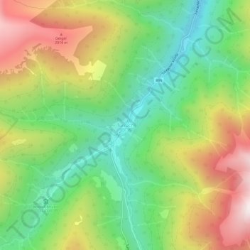
Name: Turrach topographic map, elevation, terrain.
Location: Turrach, Stadl-Predlitz, Bezirk Murau, Styria, 8862, Austria (46.94320 13.86552 46.98320 13.90552)
Average elevation: 5,272 ft
Minimum elevation: 3,914 ft
Maximum elevation: 7,192 ft
Thank you for supporting this site ❤️
Make a donation
Make a donation
Gear up for your next adventure:
As an Amazon Associate, this site earns from qualifying purchases at no extra cost to you.