
Ribeira de Nisa topographic map
Interactive map
Click on the map to display elevation.
About this map
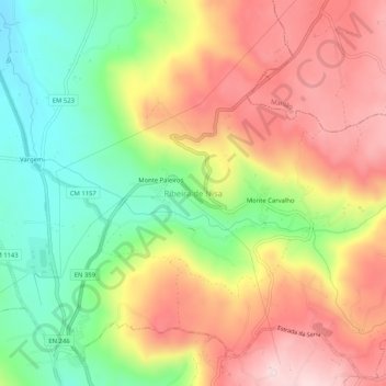
Name: Ribeira de Nisa topographic map, elevation, terrain.
Location: Ribeira de Nisa, Portalegre, 7300-431, Portugal (39.30727 -7.44474 39.34727 -7.40474)
Average elevation: 1,877 ft
Minimum elevation: 1,355 ft
Maximum elevation: 2,392 ft
Other topographic maps
Click on a map to view its topography, its elevation and its terrain.
Penhas
Portugal > Portalegre > Portalegre
Penhas, Reguengo e São Julião, Portalegre, 7300-321, Portugal
Average elevation: 2,224 ft
São Julião
Portugal > Portalegre > Portalegre
São Julião, Portalegre, 7300-459, Portugal
Average elevation: 2,116 ft
Reguengo e São Julião
Portugal > Portalegre > Portalegre
Reguengo e São Julião, Portalegre, Portugal
Average elevation: 1,975 ft
Ribeira de Nisa e Carreiras
Portugal > Portalegre > Portalegre
Ribeira de Nisa e Carreiras, Portalegre, Portugal
Average elevation: 1,726 ft