
Puigpunyent topographic map
Interactive map
Click on the map to display elevation.
About this map
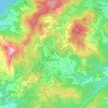
Name: Puigpunyent topographic map, elevation, terrain.
Location: Puigpunyent, Serra de Tramuntana, Balearische Inseln, Spanien (39.59105 2.48335 39.67198 2.59149)
Average elevation: 1,286 ft
Minimum elevation: -3 ft
Maximum elevation: 3,327 ft
Other topographic maps
Click on a map to view its topography, its elevation and its terrain.
Sóller
Spanien > Balearische Inseln > Serra de Tramuntana
Sóller, Serra de Tramuntana, Balearische Inseln, Spanien
Average elevation: 1,234 ft