Geolocate

Vagnas topographic map

Click on the map to display elevation.

About this map

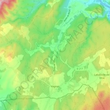
Name: Vagnas topographic map, elevation, terrain.

Location: Vagnas, Largentière, Ardèche, Auvergne-Rhône-Alpes, Metropolitan France, 07150, France (44.33826 4.30543 44.38746 4.38767)

Average elevation: 745 ft

Minimum elevation: 253 ft

Maximum elevation: 1,552 ft

Other topographic maps

Click on a map to view its topography, its elevation and its terrain.

La Chirouze

France > Auvergne-Rhône-Alpes > Ardèche > Saint-Christol

Average elevation: 2,559 ft

Arcoules

France > Auvergne-Rhône-Alpes > Ardèche > Limony

Average elevation: 709 ft

Gear up for your next adventure:

🔪Outdoor Multitools - Essential survival tools for gear repair and field use
🛰️Satellite Messengers - Emergency SOS and two-way messaging for off-grid adventures
🧦Hiking Socks - Comfortable socks to prevent blisters on long hikes
🔦LED Headlamp - Bright and durable LED headlamp for night navigation
🕶️Glacier Sunglasses - Side shields to protect eyes from high-altitude snow glare

As an Amazon Associate, this site earns from qualifying purchases at no extra cost to you.