Geolocate

Columbia topographic map

Click on the map to display elevation.

About this map

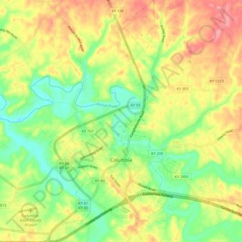
Name: Columbia topographic map, elevation, terrain.

Location: Columbia, Adair County, Kentucky, 42728, United States (37.07337 -85.33907 37.16016 -85.27944)

Average elevation: 791 ft

Minimum elevation: 627 ft

Maximum elevation: 978 ft

Adair County trails, hiking, mountain biking, running and outdoor activities

Other topographic maps

Click on a map to view its topography, its elevation and its terrain.

Knifley

United States > Kentucky > Adair County

Average elevation: 817 ft

Ella

United States > Kentucky > Adair County

Average elevation: 945 ft

Chance

United States > Kentucky > Adair County

Average elevation: 906 ft

Ella

United States > Kentucky > Adair County

Average elevation: 945 ft

Flatwood

United States > Kentucky > Adair County

Average elevation: 827 ft

Gear up for your next adventure:

🔋Solar Power Banks - Keep your GPS and phone charged in remote wilderness areas
🌡️Handheld Weather Meters - Measure wind, temp, and pressure for safe mountain travel
🪶LED Camping Lantern - Bright lantern for camp lighting
🛌Ultralight Sleeping Bags - Compact down bags for cold nights in the wilderness
📷Action Cameras - Rugged cameras to document your journeys across rugged terrain

As an Amazon Associate, this site earns from qualifying purchases at no extra cost to you.