
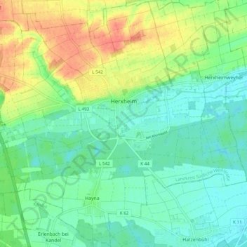
Herxheim topographic map
Interactive map
Click on the map to display elevation.
About this map
Name: Herxheim topographic map, elevation, terrain.
Average elevation: 427 ft
Minimum elevation: 367 ft
Maximum elevation: 531 ft
Other topographic maps
Click on a map to view its topography, its elevation and its terrain.
Brunnel
Germany > Rhineland-Palatinate > Landkreis Südliche Weinstraße > Steinfeld
Brunnel, Steinfeld, Bad Bergzabern, Landkreis Südliche Weinstraße, Rhineland-Palatinate, Germany
Average elevation: 459 ft
Vorderweidenthal
Germany > Rhineland-Palatinate > Landkreis Südliche Weinstraße > Vorderweidenthal
Vorderweidenthal, Bad Bergzabern, Landkreis Südliche Weinstraße, Rhineland-Palatinate, Germany
Average elevation: 978 ft
Altdorf
Germany > Rhineland-Palatinate > Landkreis Südliche Weinstraße > Altdorf
Altdorf, Edenkoben, Landkreis Südliche Weinstraße, Rhineland-Palatinate, 67482, Germany
Average elevation: 486 ft
Dierbach
Germany > Rhineland-Palatinate > Landkreis Südliche Weinstraße > Dierbach
Dierbach, Bad Bergzabern, Landkreis Südliche Weinstraße, Rhineland-Palatinate, Germany
Average elevation: 531 ft