
gmina Miedźno topographic map
Interactive map
Click on the map to display elevation.
About this map
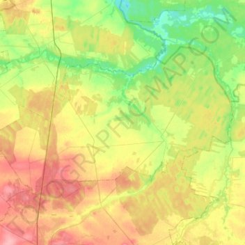
Name: gmina Miedźno topographic map, elevation, terrain.
Location: gmina Miedźno, Kłobuck County, Silesian Voivodeship, Poland (50.93612 18.87363 51.03553 19.12773)
Average elevation: 722 ft
Minimum elevation: 587 ft
Maximum elevation: 883 ft
Other topographic maps
Click on a map to view its topography, its elevation and its terrain.
Przedmieście
Poland > Silesian Voivodeship > Kłobuck County > Zawady
Przedmieście, Zawady, gmina Popów, Kłobuck County, Silesian Voivodeship, 42-110, Poland
Average elevation: 696 ft
gmina Popów
Poland > Silesian Voivodeship > Kłobuck County
gmina Popów, Kłobuck County, Silesian Voivodeship, 42-110, Poland
Average elevation: 696 ft
Zbory
Poland > Silesian Voivodeship > Kłobuck County
Zbory, gmina Popów, Kłobuck County, Silesian Voivodeship, 42-110, Poland
Average elevation: 696 ft