
Michałowo topographic map
Interactive map
Click on the map to display elevation.
About this map
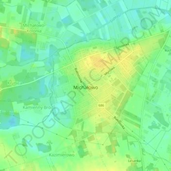
Name: Michałowo topographic map, elevation, terrain.
Average elevation: 492 ft
Minimum elevation: 456 ft
Maximum elevation: 531 ft
Other topographic maps
Click on a map to view its topography, its elevation and its terrain.
Mostowlany
Poland > Podlaskie Voivodeship > Białystok County
Mostowlany, gmina Gródek, Białystok County, Podlaskie Voivodeship, Poland
Average elevation: 489 ft
Gródek
Poland > Podlaskie Voivodeship > Białystok County
Gródek, gmina Gródek, Białystok County, Podlaskie Voivodeship, 16-040, Poland
Average elevation: 482 ft
Zabłudów
Poland > Podlaskie Voivodeship > Białystok County
Zabłudów, gmina Zabłudów, Białystok County, Podlaskie Voivodeship, 16-060, Poland
Average elevation: 509 ft
Mińce
Poland > Podlaskie Voivodeship > Białystok County > Mińce
Mińce, gmina Choroszcz, Białystok County, Podlaskie Voivodeship, Poland
Average elevation: 449 ft
Wasilków
Poland > Podlaskie Voivodeship > Białystok County
Wasilków, gmina Wasilków, Białystok County, Podlaskie Voivodeship, 16-010, Poland
Average elevation: 446 ft
Krynica
Poland > Podlaskie Voivodeship > Białystok County
Krynica, gmina Michałowo, Białystok County, Podlaskie Voivodeship, Poland
Average elevation: 499 ft