

Hasliberg topographic map
Click on the map to display elevation.
Hasliberg
The main inhabited area of Hasliberg is situated on a south-west facing terrace above the valley of the river Aare, at an approximate altitude of 1,000 m (3,300 ft). Spread out along this terrace are the villages of Hohfluh, Wasserwendi, Goldern and Reuti. To the north and east the municipality spreads out onto higher ground, reaching its highest points at the summits of Glogghüs at 2,534 m (8,314 ft), and Planplatten at 2,245 m (7,365 ft).
About this map
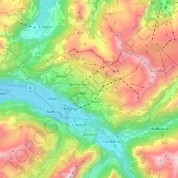
Name: Hasliberg topographic map, elevation, terrain.
Average elevation: 4,639 ft
Minimum elevation: 1,883 ft
Maximum elevation: 8,652 ft
Other topographic maps
Click on a map to view its topography, its elevation and its terrain.
Burglauenen
Switzerland > Bern > Interlaken-Oberhasli administrative district > Grindelwald
Average elevation: 4,616 ft
Titlis
Switzerland > Bern > Interlaken-Oberhasli administrative district > Innertkirchen
Average elevation: 8,268 ft
Brienz
Switzerland > Bern > Interlaken-Oberhasli administrative district > Brienz (BE)
Average elevation: 2,657 ft
Schilthorn
Switzerland > Bern > Interlaken-Oberhasli administrative district > Lauterbrunnen
Average elevation: 8,054 ft