
Sobrido topographic map
Interactive map
Click on the map to display elevation.
About this map
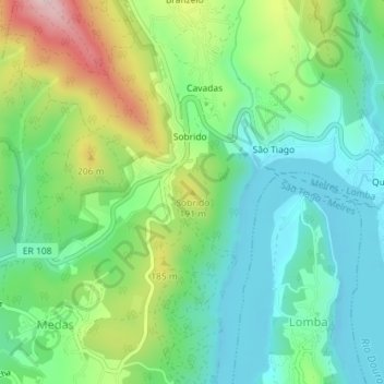
Name: Sobrido topographic map, elevation, terrain.
Location: Sobrido, Gondomar, Porto, 4515-638, Portugal (41.07076 -8.42164 41.07086 -8.42154)
Average elevation: 331 ft
Minimum elevation: 20 ft
Maximum elevation: 991 ft
Other topographic maps
Click on a map to view its topography, its elevation and its terrain.
São Pedro da Cova
São Pedro da Cova, Gondomar, Porto, 4510-398, Portugal
Average elevation: 404 ft
Vila Verde
Vila Verde, Gondomar (São Cosme), Valbom e Jovim, Gondomar, Porto, 4300-378, Portugal
Average elevation: 213 ft