
Thank you for supporting this site ❤️
Make a donation
Make a donation
Gear up for your next adventure:
As an Amazon Associate, this site earns from qualifying purchases at no extra cost to you.
Varsi topographic map
Click on the map to display elevation.
Thank you for supporting this site ❤️
Make a donation
Make a donation
Gear up for your next adventure:
As an Amazon Associate, this site earns from qualifying purchases at no extra cost to you.
About this map
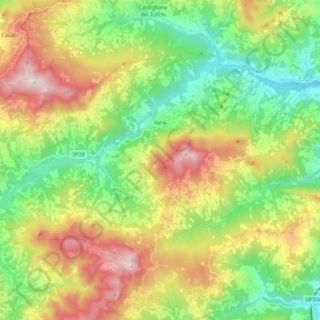
Name: Varsi topographic map, elevation, terrain.
Location: Varsi, Parma, Emilia-Romagna, 43049, Italy (44.59864 9.73706 44.69262 9.93492)
Average elevation: 2,077 ft
Minimum elevation: 732 ft
Maximum elevation: 4,245 ft
Thank you for supporting this site ❤️
Make a donation
Make a donation
Gear up for your next adventure:
As an Amazon Associate, this site earns from qualifying purchases at no extra cost to you.