Geolocate

Sarnath topographic map

Click on the map to display elevation.

About this map

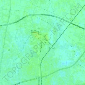
Name: Sarnath topographic map, elevation, terrain.

Location: Sarnath, Sadar, Varanasi, Uttar Pradesh, 221007, India (25.35763 83.00760 25.39763 83.04760)

Average elevation: 256 ft

Minimum elevation: 240 ft

Maximum elevation: 272 ft

Other topographic maps

Click on a map to view its topography, its elevation and its terrain.

Ananad Bagh

India > Uttar Pradesh > Sadar > Varanasi

Average elevation: 246 ft

Gear up for your next adventure:

🔭Stargazing Telescopes - Perfect for camping in low-light pollution areas shown on maps
🧦Hiking Socks - Comfortable socks to prevent blisters on long hikes
🏥Hiking First Aid Kits - Comprehensive medical kits for remote trail injuries
📌Outdoor GPS Map App - Apps and devices for digital topographic navigation
👓Polarized Sunglasses - Outdoor sunglasses for glare reduction

As an Amazon Associate, this site earns from qualifying purchases at no extra cost to you.