
Make a donation
Gear up for your next adventure:
As an Amazon Associate, this site earns from qualifying purchases at no extra cost to you.
Al Reem Island topographic map
Click on the map to display elevation.
Make a donation
Gear up for your next adventure:
As an Amazon Associate, this site earns from qualifying purchases at no extra cost to you.
About this map
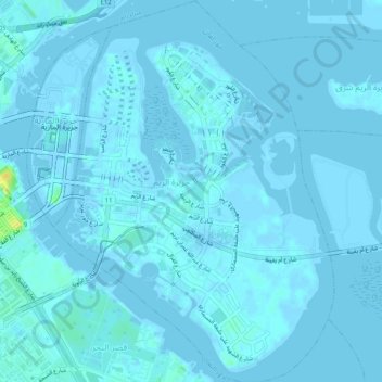
Name: Al Reem Island topographic map, elevation, terrain.
Average elevation: 3 ft
Minimum elevation: -23 ft
Maximum elevation: 89 ft
Make a donation
Gear up for your next adventure:
As an Amazon Associate, this site earns from qualifying purchases at no extra cost to you.
Other topographic maps
Click on a map to view its topography, its elevation and its terrain.
Abu Al Abyad
United Arab Emirates > Abu Dhabi Emirate > Abu Dhabi > Abu Al Abyad Island
Average elevation: 13 ft
Al Wathba
United Arab Emirates > Abu Dhabi Emirate > Abu Dhabi > Al Wathbah > Al Wathba
Average elevation: 164 ft
MBZ City Park
United Arab Emirates > Abu Dhabi Emirate > Abu Dhabi > Mohamed Bin Zayed City
Average elevation: 26 ft
Make a donation
Gear up for your next adventure:
As an Amazon Associate, this site earns from qualifying purchases at no extra cost to you.