
Warner topographic map
Click on the map to display elevation.
Warner
Mount Kearsarge, elevation 2,937 feet (895 m) above sea level, located in the extreme north of the town, is the highest point in Warner. Two state parks are located on the mountain: Rollins State Park in Warner and Winslow State Park in Wilmot. Mount Kearsarge is a popular hiking destination, due both to its bare, rocky summit, and to the fact that a paved road climbs from Rollins State Park to within a half mile of the summit. The peak is the highest point along the 75-mile (121 km) Sunapee-Ragged-Kearsarge Greenway, a hiking trail which links 10 towns and encircles the Lake Sunapee region of western New Hampshire.
About this map
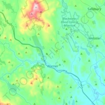
Name: Warner topographic map, elevation, terrain.
Location: Warner, Merrimack County, New Hampshire, United States (43.21310 -71.92410 43.39525 -71.72581)
Average elevation: 810 ft
Minimum elevation: 338 ft
Maximum elevation: 2,907 ft
Merrimack County trails, hiking, mountain biking, running and outdoor activities
Other topographic maps
Click on a map to view its topography, its elevation and its terrain.
Ragged Mountain
United States > New Hampshire > Merrimack County > Danbury
Average elevation: 1,627 ft
Kelleys Corner
United States > New Hampshire > Merrimack County > Chichester
Average elevation: 518 ft
Newbury
United States > New Hampshire > Merrimack County > Newbury > Newbury
According to the United States Census Bureau, the town has a total area of 38.1 square miles (98.7 km2), of which 35.8 square miles (92.8 km2) are land and 2.3 square miles (5.9 km2) are water, comprising 5.94% of the town. Mount Sunapee, the highest point in town, has an elevation of 2,726 feet (831 m) above…
Average elevation: 1,496 ft
North Pembroke
United States > New Hampshire > Merrimack County > Pembroke > North Pembroke
Average elevation: 650 ft
Salisbury Heights
United States > New Hampshire > Merrimack County > Salisbury > Salisbury Heights
Average elevation: 804 ft