
Thank you for supporting this site ❤️
Make a donation
Make a donation
Gear up for your next adventure:
As an Amazon Associate, this site earns from qualifying purchases at no extra cost to you.
白龙江 topographic map
Click on the map to display elevation.
Thank you for supporting this site ❤️
Make a donation
Make a donation
Gear up for your next adventure:
As an Amazon Associate, this site earns from qualifying purchases at no extra cost to you.
About this map
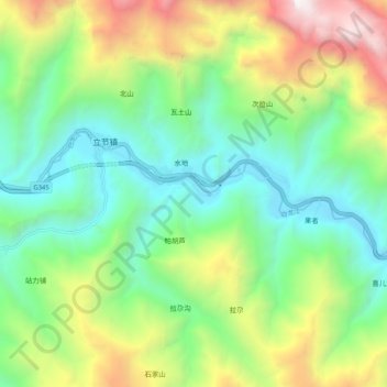
Name: 白龙江 topographic map, elevation, terrain.
Location: 白龙江, 立节镇, 舟曲县, 甘南藏族自治州, 甘肃省, 746300, 中国 (33.87165 104.03765 33.89947 104.14128)
Average elevation: 7,415 ft
Minimum elevation: 4,951 ft
Maximum elevation: 12,385 ft
Thank you for supporting this site ❤️
Make a donation
Make a donation
Gear up for your next adventure:
As an Amazon Associate, this site earns from qualifying purchases at no extra cost to you.