
Make a donation
Gear up for your next adventure:
As an Amazon Associate, this site earns from qualifying purchases at no extra cost to you.
Mount Makalu topographic map
Click on the map to display elevation.
Make a donation
Gear up for your next adventure:
As an Amazon Associate, this site earns from qualifying purchases at no extra cost to you.
Mount Makalu
Makalu (Nepali: मकालु हिमाल, romanized: Makālu himāl; Chinese: 马卡鲁峰; pinyin: Mǎkǎlǔ Fēng) is the fifth-highest mountain on Earth, with a summit at an elevation of 8,485 metres (27,838 ft) AMSL. It is located in the Mahalangur Himalayas 19 km (12 mi) southeast of Mount Everest, on the China–Nepal border. One of the eight-thousanders, Makalu is an isolated peak shaped like a four-sided pyramid.
Make a donation
Gear up for your next adventure:
As an Amazon Associate, this site earns from qualifying purchases at no extra cost to you.
About this map
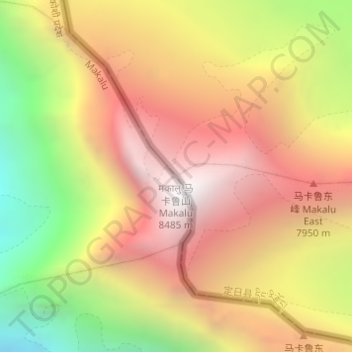
Name: Mount Makalu topographic map, elevation, terrain.
Average elevation: 24,537 ft
Minimum elevation: 20,679 ft
Maximum elevation: 27,523 ft
Make a donation
Gear up for your next adventure:
As an Amazon Associate, this site earns from qualifying purchases at no extra cost to you.
Other topographic maps
Click on a map to view its topography, its elevation and its terrain.
Shelkar
China > Tibet > Tingri County
The town lies 7 kilometres (4.3 mi) off the Friendship Highway between Lhatse and Tingri, at an altitude of about 4,300 metres (14,100 ft), at the southern foot of 5,260 metres (17,260 ft) high Gyatso La. It is approximately 60 kilometres (37 mi) north-west of Mount Everest and just over 50 kilometres (31 mi)…
Average elevation: 15,850 ft
Make a donation
Gear up for your next adventure:
As an Amazon Associate, this site earns from qualifying purchases at no extra cost to you.