
Adendorf topographic map
Interactive map
Click on the map to display elevation.
About this map
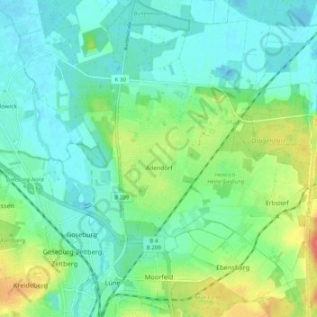
Name: Adendorf topographic map, elevation, terrain.
Location: Adendorf, Lüneburg, Niedersachsen, 21365, Deutschland (53.25402 10.42318 53.31282 10.49820)
Average elevation: 69 ft
Minimum elevation: 16 ft
Maximum elevation: 200 ft
Other topographic maps
Click on a map to view its topography, its elevation and its terrain.
Bardowick
Deutschland > Niedersachsen > Lüneburg
Bardowick, Samtgemeinde Bardowick, Lüneburg, Niedersachsen, 21357, Deutschland
Average elevation: 43 ft
Lüneburg
Deutschland > Niedersachsen > Lüneburg
Lüneburg, Niedersachsen, Deutschland
Average elevation: 115 ft