Geolocate

Pisa topographic map

Click on the map to display elevation.

About this map

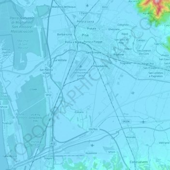
Name: Pisa topographic map, elevation, terrain.

Location: Pisa, Tuscany, Italy (43.58072 10.26846 43.75077 10.45628)

Average elevation: 36 ft

Minimum elevation: -16 ft

Maximum elevation: 2,329 ft

Other topographic maps

Click on a map to view its topography, its elevation and its terrain.

Montecalvoli

Italy > Tuscany > Pisa > Santa Maria a Monte

Average elevation: 108 ft

Montecastello

Italy > Tuscany > Pisa > Pontedera

Average elevation: 243 ft

Pieve di Santa Luce

Italy > Tuscany > Pisa

Average elevation: 459 ft

Garetto Basso

Italy > Tuscany > Pisa > Chianni

Average elevation: 899 ft

Casciana Alta

Italy > Tuscany > Pisa

Average elevation: 446 ft

Laura

Italy > Tuscany > Pisa

Average elevation: 213 ft

Casciana Alta

Italy > Tuscany > Pisa

Average elevation: 446 ft

Santo Pietro Belvedere

Italy > Tuscany > Pisa

Average elevation: 223 ft

Casciana Terme

Italy > Tuscany > Pisa

Average elevation: 492 ft

Partino

Italy > Tuscany > Pisa > Palaia

Average elevation: 390 ft

Ghizzano

Italy > Tuscany > Pisa > Peccioli

Average elevation: 338 ft

Sassa

Italy > Tuscany > Pisa > Montecatini Val di Cecina

Average elevation: 748 ft

San Casciano

Italy > Tuscany > Pisa > Cascina

Average elevation: 187 ft

Gear up for your next adventure:

🏕️Family Camping Gear - Essentials for group camping trips
📡GPS Antenna Upgrade - Enhance GPS reception in remote terrain
🛡️Bear Spray Outdoor - Protection in bear country hikes
🧢Sun Protection Hats - Wide-brimmed and UPF-rated hats for high-altitude sun safety
🧦Merino Wool Socks - Moisture-wicking, blister-preventing socks for long treks

As an Amazon Associate, this site earns from qualifying purchases at no extra cost to you.