
Rußbach am Paß Gschütt topographic map
Interactive map
Click on the map to display elevation.
About this map
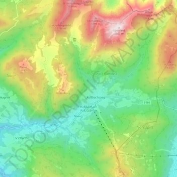
Name: Rußbach am Paß Gschütt topographic map, elevation, terrain.
Average elevation: 3,848 ft
Minimum elevation: 2,195 ft
Maximum elevation: 6,617 ft
Dörfer: Rußbach am Paß Gschütt • Strubegg | Weiler: Erlbach | Rotten: Bodenberg • Elendgraben • Gseng • Hornegg • Rußbachsaag • Rußegg • Schattau • Schattauhöhe • Triebenegg • Wiesenau | Häusergruppe: Scheiben