
ศาลาด่าน topographic map
Interactive map
Click on the map to display elevation.
About this map
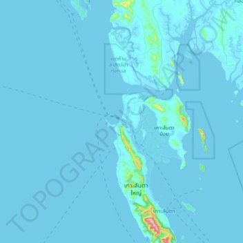
Name: ศาลาด่าน topographic map, elevation, terrain.
Location: ศาลาด่าน, Provinz Krabi, 81550, Thailand (7.48928 98.87785 7.80928 99.19785)
Average elevation: 26 ft
Minimum elevation: -13 ft
Maximum elevation: 1,532 ft
Other topographic maps
Click on a map to view its topography, its elevation and its terrain.
หมู่เกาะพีพี
Thailand > Provinz Krabi > หาดแหลมทอง
หมู่เกาะพีพี, หาดแหลมทอง, Provinz Krabi, Thailand
Average elevation: 7 ft